The Far North of Northland, North Island
5th April, Cape Reigna, New Zealand
The first thing I did this morning was to phone my mum to wish her a happy birthday (her birthday is on the 3rd but New Zealand is +11 hours GMT). The thing about travelling is that you kind of lose track of days after a while. It can be difficult enough remembering birthdays of friends and family at the best of times but now there is the added complication of trying to remember them two weeks in advance so that birthday cards and presents arrive in time. Thank goodness for Interflora online!
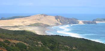
Ian and I left Paihia and headed for Cape Reigna. It took a good two hours drive to get there. The last 20km was on unsealed road which meant that we had to drive very slowly - it was a bit tedious but the view in the end was well worth it. Contrary to popular belief, Cape Reigna is neither the most northly point of New Zealand, nor is it the most westerly point. However, facing the South Pacific Ocean and the Tasman Sea, the lighthouse certainly has an end-of-the-country feel to it.
View from Cape Reigna.
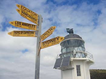
Luckily we had lovely blue skies which gave the white-painted lighthouse more definition. The last lighthouse we visited was at Byron Bay in Australia and on that day it was overcast and the lighthouse seemed to blend in with the background - not ideal for photographs (or for nearby sailors, for that matter!).
There is a sign near to the lighthouse with directions of where certain major cities are and London is apparently 19271km away. Gee, that's helped me get my bearings!
Anyone up for a 19,271km journey?
On the way back, we stopped off at part of the 90-mile beach. According to the guide books, if this were metricated to kilometres, it would provide a more accurate measure of the overall distance. This area is renowned for its huge sand dunes - an ideal place for sand toboganning.
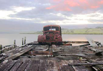
Leaving Cape Reigna, we drove on down on the westerly side of North Island - an area known as Northland - and through a village called Kohukohu. Barbara had mentioned this place as worth a look, mainly because it was where Ted was born. Once upon a time, it had been a prosperous place, but now it would be generous to call it a two-horse town. We spotted a jetty along the shore that, like the car upon it, had definitely seen better, more prosperous days.
Not-so-prosperous Kohukohu.
We continued on to catch the Hokianga car ferry across to Rawene. By the time we reached the other side it was dark. We drove to Omapere where we found some accommodation just in time. Trying to find our accommodation in the dark wasn't easy - Omapere is a small town and by 8pm, it was also a sleepy town. The only service station in town was about to close and after all that driving, we hadn't had any dinner yet. Thankfully, the lady running the backpackers that we ended up at, took pity on us and raided her freezer, digging out eggs, potatoes, an onion, lamb and mint sausages and baked beans. We bought just the sausages and beans from her and set about making dinner. It might have been a late dinner, but like our 20km journey along the rough road this morning, some things are worth persevering with!